")
")
")
")
")
In 2012 i wrote about survey plan scams and it went viral. 8 years later in 2020, the need to re-write about these kinds of scams are just as important as it was then for people to be aware of the dangers of being in possession of a very fraudulent survey plan since many crooked real estate companies are springing up everywhere more especially in Ibeju Lekki. For those who have not seen a survey plan and you want to differentiate between a genuine survey plan from a fake one, please read this article to learn a lot about survey plans and tricks on how to avoid being a victim of a Survey plan scam.
Being a personal victim of 3-4 horrible land purchases using dishonest and wicked surveyors in the past, I am using this medium to expose the lengths these terrible surveyors would go to lie, cheat and produce fake Survey plans that already have problems hereby leading to so many land purchase wahalas. Most of them parading themselves as Surveyors are Quacks and not licensed to practice. They actively collude with Omoniles, shady Real estate companies and Land fraudsters to cause chaos. Some of the irreprehensible things these rogue surveyors engage in include the following:
Distort survey plans, forge signatures, steal (Free from Acquisition) Stamps from licensed surveyors, fabricate square meters to make a land look large but by the time the land is being measured after purchase, you will discover its some few hundred meters short. They also fail to put the beacon numbers on the land to reflect the beacon points where the property starts and ends. They also re-create fictious existing roads that would never be approved and generally destroy the plan of the whole community.
The greatest crime these duplicitous surveyors commit is going to the land to chart fake coordinates and that to me kills the potential buyer. Naturally, a surveyor should take coordinates of the area using their GPS machine to compare it with the master plan obtainable at the Surveyor general’s office, instead, these Quacks surveyors bank on the ignorance of everyone, pick fake coordinates and tell the buyer it is free from acquisition while the buyer would accept it without asking questions. By the time buyer decides to use this dodgy survey plan to perfect his governor’s consent, ratification or title documents, he will get a letter from Alausa querying the survey plan stating the property is not free from Government acquisition, has wrong charting coordinates or that land that should ordinarily be located in Epe will be showing Ibeju Lekki on the master survey plan at Alausa.
With this in mind, I will try to educate you guys about 9 pros and cons of a survey plan and what you should watch out for. I will give you some practical experiences I have encountered previously so as to guide and aid you to avoid making the same mistakes a lot of Nigerians including yours truly encountered in the hands of these unprincipled surveyors. Its quite a long read so get your cup of coffee and enjoy the ride.
1. PROBLEM WITH SURVEY PLAN NAME
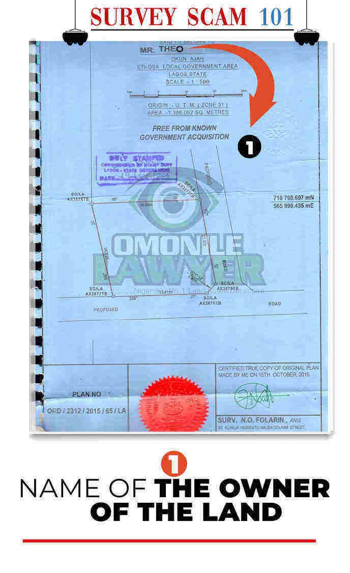
The first thing you have to look out for in a survey plan is the Name. An example or illustration of a survey plan with the name is attached above. Without the name of the owner of the property written properly, the whole survey plan is void. A simple spelling mistake of the name of the property owner can nullify the whole survey plan and it's very important to make sure you look at the name properly before accepting it from the surveyor.
CASE STUDY:
A buyer approached a property speculator whose name was Mr. DIPO AJIBOLA to purchase his property. He asked for his survey plan to conduct his own independent verification to confirm whether the land was free. When the buyer got to the Surveyor general’s office to verify if Mr. DIPO AJIBOLA's survey was duly registered and lodged, he found another person with the name Mr. DAPO AJIBOLA who purchased land in the same area and registered his own (Notice the difference in names between DIPO and DAPO) Apparently the Omoniles had discovered this error and did not alert the true owner of the land Mr. DIPO AJIBOLA and the owner himself did not spot it in time.
It was very difficult for Mr. DIPO AJIBOLA to do a change of name correction and even prove he was the owner of the land. The mental stress and anguish Mr DIPO AJIBOLA encountered during that period was unimaginable because once the name has been lodged in the database or original list as the true owner of the survey, it means all other documents must follow the same pattern because of that name problem and it automatically leads to identity theft or false misrepresentation of that person.
As for the surveyor, he is nowhere to be found since and the real Mr. DIPO AJIBOLA had to spend money again to redo the survey plan in his name and pay other fees to rectify that simple error before he could attempt to resell the land. So Once you see the slightest spelling error in the name from a Survey Plan, be very adamant that the surveyor gets the spelling correct unless it could pose problems for you. The Quack Surveyors are very good with this because they do things hurriedly without thinking and are only concerned about the money they are ripping off from you.
2. NO REGISTERED SEAL OF THE SURVEYOR
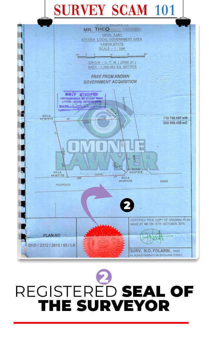
The second thing you look for in a survey plan is the Registered Seal of the Surveyor who did the Survey plan. Without this Seal please don’t even touch the survey plan. Most of these quacks don’t have the seal so they show unsuspecting land buyers survey plans without it. The ones that think they are smart end up stealing the Seal of a licensed Surveyor but you won't see the registration number there. Always ask for the Registration Card of the Surveyor and Check for the seal unless the whole survey plan is defective.
3. NO PROPER ADDRESS OF THE LAND'S LOCATION
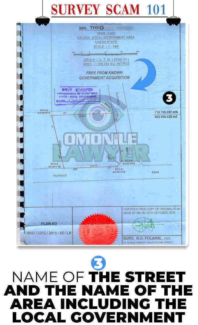
The third thing you have to look out for in a Survey Plan is the Address. This is also where you will find a lot of fraudulent things done by the surveyor and Omonile. Because the Omoniles want to do something dodgy, they won't put the name of the street, Area or Local government correctly.
Imagine you see a Survey plan and the address written is (At Ajah) Where is at Ajah? Ajah has over 100 towns and communities. So when the surveyor writes (At Ajah) Know there is a problem. The only permissible excuse for this is if the Land is located in an undeveloped area and there are no visible layouts or perimeter boundaries to locate the area in question, then it's permissible to just use that AT AJAH (But the adjoining community must be added. E.g AT OKUN AJAH WITHIN AJAH IN ETI-OSA LOCAL GOVERNMENT AREA.
The Omoniles use this to hoodwink people into buying wrong places they shouldn't buy. Because the person is interested in buying a good place they have not set their eyes on, they fall victim of the survey plan and its mostly Nigerians living abroad they use this scam for. (Beware of them)***
Also, check properly for the local government area written in the Survey plan unless it could alter the whole thing. E.g BOGIJE is in IBEJU LEKKI LOCAL GOVERNMENT and not in ETI-OSA. If your survey plan shows that Bogije is in Eti-Osa local government or Ogba is in Ojodu Local Government, it is a defective plan. Always know the local government the Land is being located unless it will cost you.
4. DISCREPANCIES WITH THE SIZE OF THE LAND
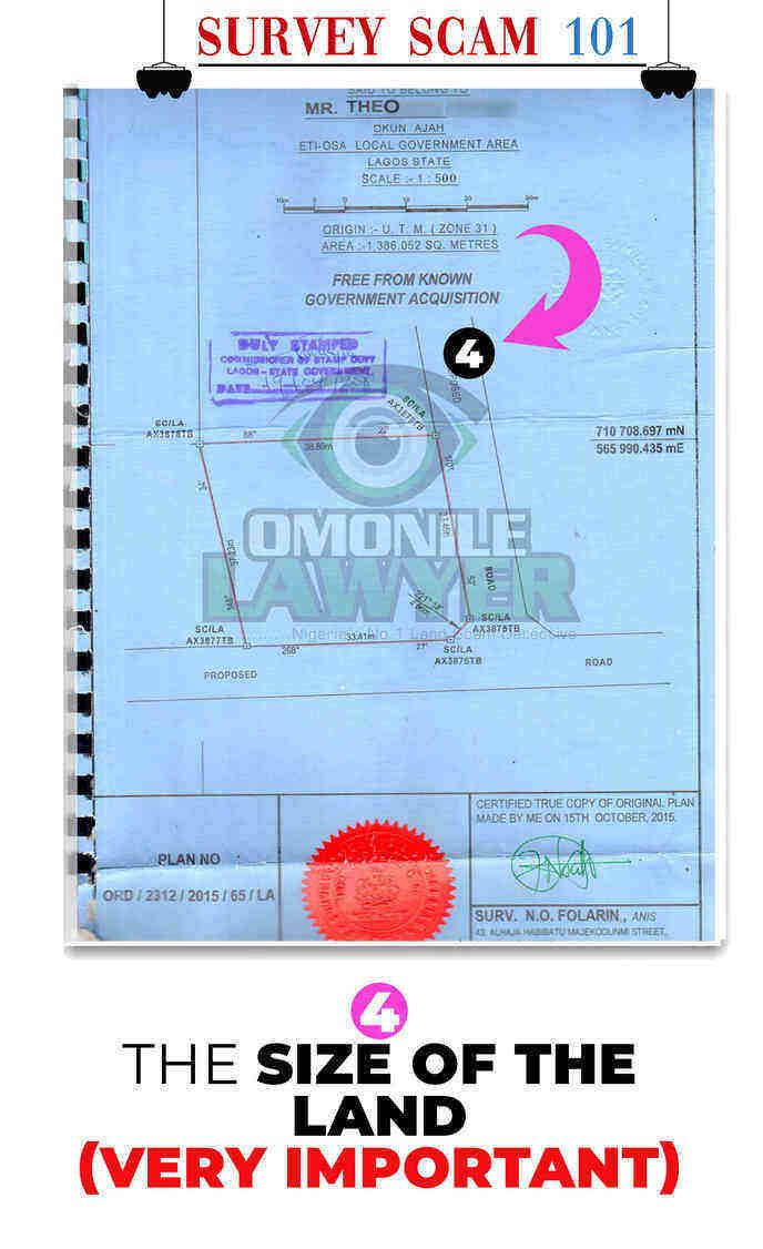
Fourthly one of the most important things in a survey plan is the Area or the size of the land. This is one area these fraudulent surveyors perform the most havoc to the owner of the land.
Because they don’t come with the proper tools to measure the land, they don’t get the exact square meters of the land. They either short change or unnecessarily add extra meters to make it look larger than normal or fabricate corner pieces. This is where every potential landowner must sacrifice time to visit the land when they are measuring the land or send a representative.
Normally there is a surveying instrument they use to just get the square meters of the coordinates after measuring it but I don’t trust these boys. The old measuring tape is fine by me. You will know exactly what you’re getting. The only reason you shouldn’t go there is ‘If you trust your surveyor’ Apart from that, you must be there with him. One meter reduced from your land will be added to another person’s land and automatically your looking at a border dispute case.
There are a plethora of cases regarding this particular issue and I will tell you a funny one that occurred in Sangotedo.
CASE STUDY
After a rigourous search had been conducted on a land at Sangotedo, I finally agreed for my client to purchase the property. When it was time to exchange contracts, the seller stated that since the property was measuring 741 square meters as reflected on his survey plan, he was not going to sell the land at the previously agreed price because he just realized that his land was a very large land and my client was buying it for cheap compared to lands of that size going for that price in the area.
This unplanned price increment led to several quarrels and the seller refused to budge because his surveyor told him his land was more than a plot and a regular plot is above 600 Square meters. We impressed on the Seller to re-measure the land to get the true value of the size of the land and he vehemently refused but the moment he saw the client’s cheque book fall off his pocket, he acceded to our request to re-measure the land. We engaged a neutral surveyor to measure the land and we ended up getting 509 square meters which were less 232 Square meters compared to what was written on his Survey Plan. When the Seller found out that his land was not even up to a full plot, he almost collapsed.
“We jejely carried out 2 left legs and left the site”
The size of a land usually determines how much the land will go for, the amount of space required to put up your building and the amount remaining for the right of way/set back. Because of this, crooked surveyors collude with owners of land to fraudulently misrepresent the actual size of the land so that they can benefit from it financially from the Seller. Also, a false size of the land will change the way you’re being assessed for your Governor’s consent/ Building Approval, so you must be very vigilant about this so you won’t get duped by these people.
5. ABSENCE OF A SURVEY PLAN NUMBER
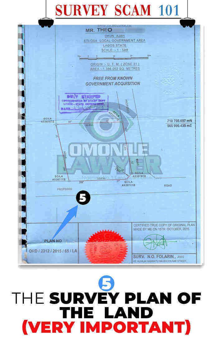
Another important part of the Survey plan that you must look out for is the Survey Plan Number. This is a vintage scam that some surveyors use to deceive people. They will draw up the whole survey plan but conveniently hide the Survey Plan number. Without a survey plan number, your survey is as good as useless. Your child’s cartoon drawings are probably worth more in value than your survey plan.
Without that Survey plan number, it cannot be lodged at the surveyor general’s office for record purposes, it cannot be used to draft your agreement, it cannot be used to trace the red copy and I cannot be used as evidence in court during a property lawsuit because of its defect from the start.
It is always at the lower left-hand corner of a survey plan and because these dodgy surveyors don’t intend to lodge the red copy they end up not giving the survey a Survey plan number. They will tell you they have lodged it but it hasn’t been lodged because there is no record file of it. Always check for the Survey plan number at first glance.
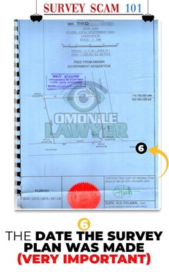
6. FRAUDULENT BACK-DATING OF A SURVEY PLAN
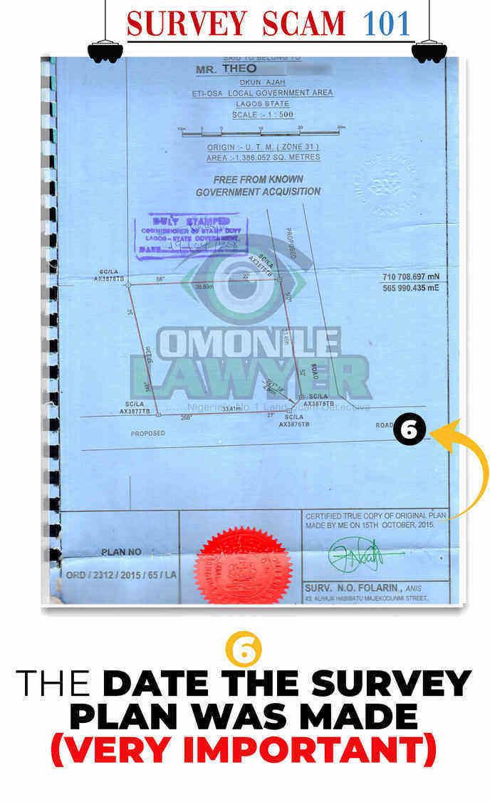
This one is the crown prince of all the Survey plan scams you can think of and that’s is the Date the Survey plan was made. This scam is known as BACK-DATING OF A SURVEY PLAN.
Naturally, if a Survey plan is being done today it should show done on the 23rd day of April 2020, but sometimes you view a very clean survey plan and you see it was done on the 25th day of March 2001!!!! You would end up wondering when was the land was bought or when was the area given an excision or C/o?
If you take this survey plan to the surveyor general’s office, you won’t see ANY COPY of the lodged survey plan because it has been fraudulently backed dated to make you believe it was done a long time ago but if you check well you will find out that it was done just probably last year. This scam is well perfected with the Owner, the agent, Surveyor and Omonile to hoodwink you into buying it. The ramifications are endless.
Case Study:
There was this land I had to do a search on at Ikorodu and I asked for the receipt. The receipt was showed that the land was purchased in 1992 while the survey plan was dated in 1997. I further inspected the Gazette of that area and it was issued in 2007. I asked him for the building plan he said he made but had not yet used and it was equally dated 1995.
I queried him how he could draw a building plan before the survey plan was done and he started giving me the greatest bulls**t stories I have ever heard. Telling me about how he owned the land in 1988 before the family who sold it to him gave him a receipt in 1992 and because he knew it was his land his architect brother measured it himself and drew the building plan in 1995 before he had money to do the survey plan in 1997.
I agreed with him and quietly took the survey plan to the surveyor general’s office to compare. The first person I saw there started laughing because he knew it was a backed dated survey plan and told me not to worry myself because there wouldn’t be any record of it. He said if I probe further that survey plan must have been done 2 or 3 years ago so as to coincide with the new gazette.
The dangers of a backdated survey plan are that it will be very difficult to process your papers when they find out and you won’t know the true history of the land because it could be another person’s land that they have stolen to confuse people into thinking its an old property and free from defect. Please shine your eyes here!
7. MISSING SIGNATURE AND LOGO OF THE SURVEYOR
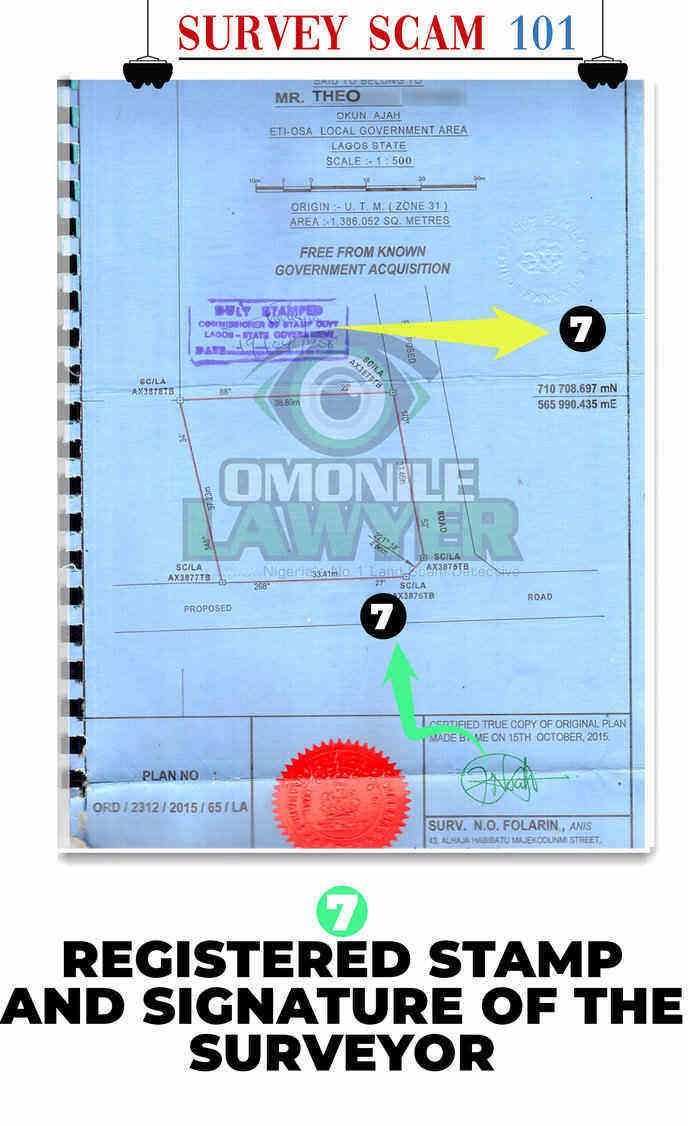
Another thing you should always look out for when doing a survey search is to look for the Logo and Signature of the Registered Surveyor. Without the Signature and logo of the person who drew up the survey plan, you are holding a dud document.
The logo usually carries the licensed Surveyor’s address and they must sign to provide the authenticity of the survey plan. Please always look out for this unless you’re dealing with quacks. In case there is a problem with the survey, the registered surveyor will assume full liability of the problem, but when you deal with a quack, how do you get your money, land or proper survey plan? Does a quack surveyor have an address?
Shine your eye Please o!
8. IRREGULAR SHAPE OF THE LAND ON THE SURVEY PLAN
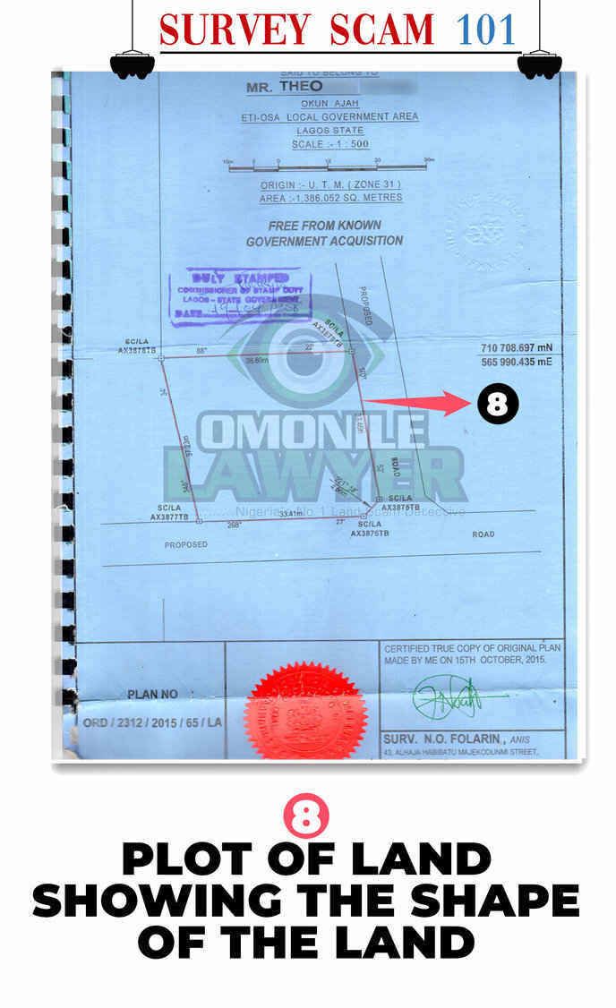
A survey plan will always show the Shape of the land and the existing road. The shape of the land is very important as it will guide your architect on how to draw the structure on the land properly and it also helps with the layout of the area so that nobody encroaches on your own land.
It’s very important to take note of that because Omoniles cash in when the existing road is not properly drawn out. That’s when you hear Omonile’s selling roads and adjoining lands to other users because the land is not properly defined in the survey. Always ask the Surveyor to show you personally where he derived the existing road from and how it connects with your land.
9. WRONG BEACON NUMBERS ON THE SURVEY PLAN
![]()
Another Survey Plan scam which is very important to note is the issue of Beacon numbers. A Beacon is a small stone on a land used to separate the 4 or 5 corners of a land to differentiate it from another land. It’s used as a boundary guide so as to erect your fence and with those beacons, you can locate your land. On top of the Stones are numbers written on it which can be found from the survey illustration below.
![]()
These Beacon numbers are Unique to only you and no 2 lands can share the same beacon numbers and its exactly what is written on the survey plan beacon numbers that must be written on the Beacon stones.
![]()
This is where the art of Scamming comes in. Naturally, the money paid to the surveyor isn’t only for the drawing of the survey plan but also to purchase the Beacon numbers/ Beacon stones from the Nigerian Institute of Surveyors and only a registered surveyor can do that and after purchasing it.
![]()
It’s the duty of the surveyor to go back to the Land to place the survey plan personally to reflect what is on the Survey plan. (IMPORTANT)***
Rather the Unprofessional ones will do the following:
- Not pay for the beacon numbers and fabricate Beacon numbers
- Has the property or Land been sold to more than one person?
- Lie to you they have purchased the Beacon numbers and have lodged the Survey plan at the Surveyor general’s office but they haven’t released them to him because of certain bureaucracies. The truth is that no beacon number was purchased neither is there any bureaucracy preventing the beacon numbers from being acquired. It’s because they haven’t lodged anything so you cannot get Beacon numbers.
- Tell you they have gone to the site to place the beacons and when you get there you will discover there is no evidence of any beacon and when you query him, he would tell you the omoniles came to remove the Beacons he placed there and you will be forced to give him more money to purchase new stones.
- They will place empty Beacon stones on the land and not inscribe any number there. Those are just plain useless stones for decoration.
- They will place the Beacon stones there and inscribe rubbish or numbers that don’t correlate because they know you won’t bother to check. When the wahala comes, it would be very difficult to get hold of the Surveyor.
- The will buy poor quality cement to mix rubbish blocks. During the rainy season, the beacon blocks will crumble and the numbers disappear.
- Omoniles will always know a quack surveyor so they monitor his every move and when he makes a mistake they will remove the beacons and tell everyone that the land has been a jungle since and they are the real owners.
- Sometimes the Omonile and dubious Surveyor will just collude together and they will place the beacons on a wrong land and you won’t know until wahala pops up.
Beacons are Very Important and you shouldn’t neglect them at all. Always go and check whether they are still there or not and cross-check with your survey plan to know whether it’s still your land.
P:S:- For the avoidance of doubt, I am not attacking the Surveying Profession. It is a Profession filled with honourable people and they have an Institute of Nigerian Surveyors that regulates them. Only deal with REGISTERED SURVEYORS AND ASK FOR THEIR CREDENTIALS. If the Surveyor has No credential, is Not registered or No business address, there should be no purchase of the property.
If you know of other Survey Plan Scams or you have been a victim of dubious surveyors who drew up fake survey plans, please tell us your story and see you in the comments section.


Gbenga Ekundayo
April 26, 2020 at 1:48 amWow Omonile lawyer. I spent 20 minutes reading this article line by line and had to read it again to truly appreciate what you have done for us with this article about survey plan scams. Its amazing the lengths people would go to cheat and deceive people with these fake survey scams in exchange for pittance. I am aware of the scams these real estate people would go to scam people with false survey plans because i was almost a victim and that’s why i appreciate this article. Continue to expose them sir. You have a very huge follower ship and God would continue to bless you for your good work educating people about the scams in Nigerian real estate. Can you please let me know the cost of surveying a land in Abijo today?
Tunji Banwo
April 27, 2020 at 12:18 amOmonile lawyer thanks for this interesting piece. I paid a surveyor for a land i bought in Ajah and he stamped on it “Free from government acquisition” but when i decided to to perfect my documents at the surveyor general’s office, i got a letter from them that the land was ” committed land”. I called the surveyor to tell him about this and he promised to get back to me. Since then, anytime i call him he relates my call to voicemail and has disappeared. What can i do? Why did he deliberately make me buy a committed land and stamp “free from acquisition” on it. What are my remedies please. I am very confused.
Folusho Adewoyin
April 27, 2020 at 4:05 pmOmonile lawyer can you please tell us the dangers of backdating a survey plan? i bought a land at Eleraingbe last year but the surveyor told me that it would cost N300K to do a proper survey while a back dated one would cost N80k He told me there is no difference between a N300K Survey and the N80K one and i paid for the N80K Survey but instead of 2019 on the survey he pushed it back to 2007. He said pushing it back would coincide with the time the excision of Eleraingbe was given in 2010 so i won’t have to pay so much money when i am perfecting my title but after reading your article i am very worried now.
Tolu Poopola
April 28, 2020 at 2:53 pmWhy does the family always insist on using their own surveyor instead of the buyer using his own surveyor? I have seen family surveyors chart lands falsely and at the end of the day problems always crop up. How do we force them to use our own surveyors instead of theirs?
Osagie Agbonifo
April 30, 2020 at 2:19 amMy surveyor collected money from me to purchase beacon numbers and to register the survey plan but after 1 year i haven’t seen any beacons on the site neither have i seen any proof of registering the survey plan. How do i get the beacons on my land and what proof must i get from him that the survey plan has been registered? Every time i call him,he is always misyarning and giving excuses why the beacons are not yet out.
Jolaosho Braimoh
May 3, 2020 at 5:22 amMy surveyor has refused to show me proof of lodgement of the redcopy of the survey plan he did for me. What can i do to get him to show me the red copy and if he refuses, how can i do it myself?
Simon Olaiya
May 4, 2020 at 3:13 amI am about to buy a land at Langbassa but i was told to do a new survey plan in my name. The owner of the land already has a survey plan in his name. Why should i do a new survey plan on the same land when there is already an existing one? Please advise.
Jude Egan
May 5, 2020 at 4:31 pmMy survey plan has no stamp or signature of the surveyor who did it. Is this survey still legal?
Ola
May 9, 2020 at 5:51 pmOmonile lawyer, you are blessed. This piece of info is so practical and not the theories being taught in textbooks. Weldone
Adedamola Adediran Wahab
June 7, 2020 at 8:54 amThanks for the info Barr. sir.
Alex ighodanyenimor
August 31, 2021 at 6:58 pmPlease i need your number
sconsurveys
May 12, 2022 at 10:31 amA survey is performed in order to locate, describe, monument, and map the boundaries and corners of a parcel of land. It might also include the topography of the parcel, and the location of buildings and other improvements made to the parcel. Professional land surveyors are trained to use an intricate combination of law, math, engineering, and physics to work out and establish property boundaries. They use specialized equipment like GPSs, prisms, software, radios and robotic total stations to complete the survey. Only those professional land surveyors licensed by Lagos State Surveyors Board are authorized to perform land surveys. As a property owner, you are able to have your property surveyed at any time but you will most likely hire a surveyor when you’re buying a home or constructing something. A survey ordered for property transfer follows its own set of standards determined by the State of Ohio. Even if you are buying a property with no plans of construction in mind, you will want to have your land surveyed so you know exactly where your boundaries of ownership lie; you’ll know what’s yours, and what’s not. A Boundary Survey will detail the exact boundaries of your land, using natural boundaries or artificial boundaries set in a written document. A “Boundary Survey” is used to identify a property’s boundary lines. In this type of survey, the surveyor will set (or recover) the property corners and produce a detailed plat or map. To accomplish this, the surveyor will research the public records and do research in the field, take measurements and perform calculations. This type of survey is necessary for construction and permit purposes.
Asa
November 17, 2022 at 9:04 amHi! I could have sworn I’ve been to this site before but after looking at many of the
posts I realized it’s new how to sell a tenant-occupied property
me. Nonetheless, I’m certainly delighted I stumbled upon it and I’ll
be book-marking it and checking back regularly!